


WAEC: GEOGRAPHY
Quizzes
-
2009 Geography WAEC Past Questions CBT
-
2010 Geography WAEC Past Questions CBT
-
2012 Geography WAEC Past Questions CBT
-
2011 Geography WAEC Past Questions CBT
-
2013 Geography WAEC Past Questions CBT
-
2014 Geography WAEC Past Questions CBT
-
2015 Geography WAEC Past Questions CBT
-
2015 Geography WAEC Theory Past Questions CBT
-
2014 Geography WAEC Theory Past Questions CBT
-
2016 Geography WAEC Past Questions CBT
-
2016 Geography WAEC Theory Past Questions CBT
-
2017 Geography WAEC Past Questions CBT
-
2017 Geography WAEC Theory Past Questions CBT
-
2018 Geography WAEC Past Questions CBT
-
2018 Geography WAEC Theory Past Questions CBT
-
2014 Geography WAEC Theory Past Questions*
-
2015 Geography WAEC Theory Past Questions CBT*
-
2016 Geography WAEC Theory Past Questions CBT*
-
2017 Geography WAEC Theory Past Questions CBT*
-
2018 Geography WAEC Theory Past Questions CBT*
-
2019 Geography WAEC Theory Past Questions CBT*
-
2019 Geography WAEC Past Questions CBTdrsoji
-
2020 Geography WAEC Objective Past Questions
-
2020 Geography WAEC Theory Past Questions
-
2014 Geography WAEC Past Questions CBT*
-
2021 Geography WAEC Objective Past Questions
-
2021 Geography WAEC Paper 2 Theory Past Questions
-
2021 Geography WAEC Paper 3 Theory Past Questions
Quiz Summary
0 of 67 Questions completed
Questions:
Information
You have already completed the quiz before. Hence you can not start it again.
Quiz is loading…
You must sign in or sign up to start the quiz.
You must first complete the following:
Results
Results
0 of 67 Questions answered correctly
Your time:
Time has elapsed
You have reached 0 of 0 point(s), (0)
Earned Point(s): 0 of 0, (0)
0 Essay(s) Pending (Possible Point(s): 0)
Categories
- Not categorized 0%
- 1
- 2
- 3
- 4
- 5
- 6
- 7
- 8
- 9
- 10
- 11
- 12
- 13
- 14
- 15
- 16
- 17
- 18
- 19
- 20
- 21
- 22
- 23
- 24
- 25
- 26
- 27
- 28
- 29
- 30
- 31
- 32
- 33
- 34
- 35
- 36
- 37
- 38
- 39
- 40
- 41
- 42
- 43
- 44
- 45
- 46
- 47
- 48
- 49
- 50
- 51
- 52
- 53
- 54
- 55
- 56
- 57
- 58
- 59
- 60
- 61
- 62
- 63
- 64
- 65
- 66
- 67
- Current
- Review
- Answered
- Correct
- Incorrect
-
Question 1 of 67
1. Question
Study the map of IKOBI DISTRICT and use it to answer Questions 1-10


The scale of the map in statement form is
CorrectIncorrect -
Question 2 of 67
2. Question
The distance from Tang to Ikobi as the crow flies is
CorrectIncorrect -
Question 3 of 67
3. Question
The drainage pattern on the map is
CorrectIncorrect -
Question 4 of 67
4. Question
The area on the map where many rivers took their source is a
CorrectIncorrect -
Question 5 of 67
5. Question
In which part of the map could a sawmill industry be sited?
CorrectIncorrect -
Question 6 of 67
6. Question
Which of the following is the most important town in the mapped area?
CorrectIncorrect -
Question 7 of 67
7. Question
Ikobi is an example of a
CorrectIncorrect -
Question 8 of 67
8. Question
The bearing of Ojoi from Ikobi is
CorrectIncorrect -
Question 9 of 67
9. Question
The likely occupation of the inhabitants of Tang is
CorrectIncorrect -
Question 10 of 67
10. Question
Which of the following towns are intervisible?
CorrectIncorrect -
Question 11 of 67
11. Question
Which of the following is a satellite of the Earth?
CorrectIncorrect -
Question 12 of 67
12. Question
Mid-latitude regions are found between
CorrectIncorrect -
Question 13 of 67
13. Question
The outer layer of the solid earth is called the
CorrectIncorrect -
Question 14 of 67
14. Question
Which of the following is an evidence to show that the earth is spherical in shape? The
CorrectIncorrect -
Question 15 of 67
15. Question
Which of the following is an igneous rock?
CorrectIncorrect -
Question 16 of 67
16. Question
Bedding plane is a characteristic of
CorrectIncorrect -
Question 17 of 67
17. Question
Which of the following land forms may occur when large scale horizontal earth movements and stresses are set up in the earth’s crust?
CorrectIncorrect -
Question 18 of 67
18. Question
Mechanical weathering due to changes in temperature occurs mainly in
CorrectIncorrect -
Question 19 of 67
19. Question
The process by which rocks are broken down and not transported is termed
CorrectIncorrect -
Question 20 of 67
20. Question
The wearing away of the sides and bottom of a river channel is called
CorrectIncorrect -
Question 21 of 67
21. Question
Wind erosion is most common in
CorrectIncorrect -
Question 22 of 67
22. Question
A piece of land almost surrounded by water is called
CorrectIncorrect -
Question 23 of 67
23. Question
Which of the following pairs are associated with the upper course of a river?
I. Deltas
II.Gorges
III. Meanders
IV. Rapids
CorrectIncorrect -
Question 24 of 67
24. Question
Steep sided, and often dry valleys in the desert are called
CorrectIncorrect -
Question 25 of 67
25. Question
To obtain the climate of a place, the average atmospheric weather conditions should be considered for about
CorrectIncorrect -
Question 26 of 67
26. Question
Isotherms are lines drawn on maps joining places having equal
CorrectIncorrect -
Question 27 of 67
27. Question
The difference between the temperatures of the hottest and coldest months of a place is the
CorrectIncorrect -
Question 28 of 67
28. Question
Precipitation includes all the following except
CorrectIncorrect -
Question 29 of 67
29. Question
The environmental lapse rate is a decrease of temperature by
CorrectIncorrect -
Question 30 of 67
30. Question
Convectional rains are typical of
CorrectIncorrect -
Question 31 of 67
31. Question
Which of the following statements is true of winds?
CorrectIncorrect -
Question 32 of 67
32. Question
A vertical section of soil through all its horizons is called
CorrectIncorrect -
Question 33 of 67
33. Question
Leaching of soil means
CorrectIncorrect -
Question 34 of 67
34. Question
Which of these methods will best help to check wind erosion?
CorrectIncorrect -
Question 35 of 67
35. Question
Which of the following are the most valuable products of Equatorial forest?
CorrectIncorrect -
Question 36 of 67
36. Question
Which of the following is not a characteristic of the Rainforest?
CorrectIncorrect -
Question 37 of 67
37. Question
Trees are deciduous when they
CorrectIncorrect -
Question 38 of 67
38. Question
The Mediterranean vegetation is described as xerophytic vegetation because it is
CorrectIncorrect -
Question 39 of 67
39. Question
The major difference between a nucleated settlement and a dispersed settlement is that a nucleated settlement
CorrectIncorrect -
Question 40 of 67
40. Question
Which of the following best describes high population growth?
CorrectIncorrect -
Question 41 of 67
41. Question
The low population density in the Middle Belt of West Africa resulted from all the following except
CorrectIncorrect -
Question 42 of 67
42. Question
The busiest ocean trade route is the
CorrectIncorrect -
Question 43 of 67
43. Question
Which of the following industries is best located near the source of raw material?
CorrectIncorrect -
Question 44 of 67
44. Question
A ginnery is a place where cotton is
CorrectIncorrect -
Question 45 of 67
45. Question
One major advantage of plantation agriculture in East Africa is that it
CorrectIncorrect -
Question 46 of 67
46. Question
Which of the following is not associated with human intervention?
CorrectIncorrect -
Question 47 of 67
47. Question
Use this map below to answer questions 47 to 50


The town marked B is
CorrectIncorrect -
Question 48 of 67
48. Question
The river marked O is the
CorrectIncorrect -
Question 49 of 67
49. Question
The area shaded and marked X is the
CorrectIncorrect -
Question 50 of 67
50. Question
The letter Y on the map represents
CorrectIncorrect -
Question 51 of 67
51. Question
1.(a) Highlight any FOUR differences between urban and rural settlements
(b) Outline any four favourable conditions for the growth of settlements
-
This response will be reviewed and graded after submission.
Grading can be reviewed and adjusted.Grading can be reviewed and adjusted.Hint
(a) Highlight any FOUR differences between urban and rural settlements
- Urban areas are usually the seat of government whereas rural areas are not
- More developed infrastructure are found in the urban areas than rural areas
- Urban settlements have more buildings than rural settlements
- The buildings in the urban areas are usually nucleated or compact whereas those of the rural areas are dispersed
- More social amenities are found in urban areas than in the rural areas
- Towns, cities, conurbation, metropolitan, megalopolis e.t.c are associated with urban settlements whereas home stead, farmstead, hamlets, and villages are associated with rural areas
- Secondary and tertiary production are associated with people in the urban areas whereas people in rural areas engage in primary production
- The urban settlement is associated with dense population while rural area is associated with scanty population
- Urban settlement is of complex lifestyle and not quiet while rural life is quiet and simple
- Urban areas are usually of large size while rural areas of small size
- Higher order service like insurance, banking are rendered by the urban settlement while such services are not applicable to the rural areas
- Houses in the urban areas are built with more superior materials like cement, bricks than rural areas that have theirs built with materials like thatch, mud, bamboo sticks. e.t.c
(b) Outline any four favourable conditions for the growth of settlements
- Fertile soil/nature of the soil
- Availability of social amenities like hospital, schools e.t.c
- Adequate water supply
- Availability of minerals
- Policy of government and its administration
- Availability of land for building
- Industrialization
- Defense
- Good transport and communication network and their accessibility
- Absence of diseases
- Presence of favourable climate
-
-
Question 52 of 67
52. Question
2.(a) State three advantages and two disadvantages of air transportation.
(b) Highlight five roles of road transportation in the promotion of economic development.
-
This response will be reviewed and graded after submission.
Grading can be reviewed and adjusted.Grading can be reviewed and adjusted.Hint
(a) State three advantages and two disadvantages of air transportation.
The advantages of air transportation
- It is the fastest means of transportation
- It saves time
- Perishable goods are best transported by air
- It makes use of great circle routes
- Air transportation by means of helicopter, can reach the farthest remotest and inhospitable areas
- In times of emergency, relief materials are transported by air
- It is used for efficient service delivery e.g. mail, goods, and services.
- It is not affected by barriers like relief, forest, oceans e.t.c
- Military operations are suited to air transport
- Routes do not require construction and maintenance
- It is best suited for passengers traffic
- No traffic congestion
- Quite comfortable and convenient
- Accidents are rare.
Disadvantages of air transport
- Not flexible
- The purchase and maintenance in term of servicing and spare parts
- It depends on other means of transport to carry goods to the final consumers
- Accidents are fatal
- Space constraint at airports for passengers
- Construction and maintenance of airport is very expensive
- The fare is expensive.
(b) Highlight five roles of road transportation in the promotion of economic development.
- Movement of people, goods and services
- Aids in national defence
- Helps in diffusion of ideas and technology
- Source of revenue generation
- Helps In accessing natural resources
- Facilitates the development of large towns and cities
- Facilitates development of tourism
- Stimulates production
- Promotes national and international trade
- Generates employment
- Facilitates development and opening of new settlement
- Encourages regional specialization in production
- Facilitates national integration and interaction
-
-
Question 53 of 67
53. Question
3(a)Describe any three factors responsible for the dominance of light industries in developing countries.
(b)Highlight any four advantages of the concentration of industries in urban areas of developing countries.
(c)Outline any three disadvantages of the concentration of industries in the urban areas of developing countries.
-
This response will be reviewed and graded after submission.
Grading can be reviewed and adjusted.Grading can be reviewed and adjusted.Hint
(a)Describe any three factors responsible for the dominance of light industries in developing countries.
- High demand for consumer goods
- Inadequate capital
- Availability of unskilled labour
- Inadequate infrastructural facilities like transportation network
- Availability of local raw materials
- They are not capital intensive
- Inadequate power supply
- Less technology
(b)Highlight any four advantages of the concentration of industries in urban areas of developing countries.
- Healthy competition are encouraged
- Industrial linkage
- Facilitates the development of skilled manpower
- Encourages the improvement in the standard of living
- Presence of skilled manpower
- Facilitates the development of infrastructure
- Facilitates the springing up of research centers
- There is inter-dependence of industries
- Development of subsidiary industries is encouraged
(c) Outline any three disadvantages of the concentration of industries in the urban areas of developing countries.
- The area is always a target during war
- Encourages uneven development
- Environmental pollution
- Destruction of ecosystem
- Crime rate increases
- Facilitates rural-urban development
- Waste management challenges
- Increase in cost of living
- Pressure on social amenities
- Slum and ghetto development
-
-
Question 54 of 67
54. Question
4.(a)Draw a sketch map of Nigeria. On the map, show and name:
(i) A delta;
(ii) A man-made lake;
(iii) A confluence town;
(iv) The Jos Plateau.
(b)Outline any three physical factors that limit the use of rivers for transportation in Nigeria.
(c)Highlight three possible solutions to the limiting factors mentioned in 4(b) above.
-
This response will be reviewed and graded after submission.
Grading can be reviewed and adjusted.Grading can be reviewed and adjusted.Hint
(a)Draw a sketch map of Nigeria. On the map, show and name:
(i) A delta;
(ii) A man-made lake;
(iii) A confluence town;
(iv) The Jos Plateau.

Sketch map of Nigeria
(b) Outline any three physical factors that limit the use of rivers for transportation in Nigeria.
- Some of the rivers are short distance flowing
- Presence of water weeds e.g. water hyacinth
- Some of the rivers are deltaic mouths
- Debris are present in some rivers, waterfall and cataracts
- Volume of rivers fluctuates seasonally
- In the rainy season, the rivers flow swiftly
- Some of the rivers are silted
(c) Highlight three possible solutions to the limiting factors mentioned in 4(b) above.
- Roads and railways should be greatly improved upon and good network provided to cushion the effects of the presence of rapids, falls and cataracts in the river.
- Rivers should be dredged
- Dams should be constructed and improvement of the status of the existing ones
- Water weeds should be cleared regularly
- Canals should be constructed
- Artificial water channels should be constructed
-
-
Question 55 of 67
55. Question
5. (a) Draw an outline map of Nigeria. On the map, show and name: (i) Abuja; (ii) three savanna vegetation belts.
(b) State four ways in which the forest vegetation of Nigeria contributes to her economy.
(c)Highlight any two problems that hinder the exploitation of forest vegetation in Nigeria.
-
This response will be reviewed and graded after submission.
Grading can be reviewed and adjusted.Grading can be reviewed and adjusted.Hint
(a) Draw an outline map of Nigeria. On the map, show and name: (i) Abuja; (ii) three savanna vegetation belts.

Outline map of Nigeria
(b) State four ways in which the forest vegetation of Nigeria contributes to her economy.
- Sources of foreign exchange earnings
- Wood serves as firewood and fuel
- Provision of raw materials for industries
- Provision of jobs for forest guard and lumber men
- Source of revenue for government
- Herbs for medicinal purposes are provided
- Provision of food in form of fruits and nuts
- Broom, baskets, bags are derived from raffia palms
- Provision of timber for construction
- For tourism and wild life
(c)Highlight any two problems that hinder the exploitation of forest vegetation in Nigeria.
- Felling of trees is risky
- Surveying to determine economic trees is quite expensive
- Heavy logs do sink at most times when being transported by water
- Inadequate motorable roads
- Poor terrain
- Soil erosion and leaching
- Degradation of the natural vegetation
- The economic trees are never seen as pure stand
- Low technology know-how
-
-
Question 56 of 67
56. Question
6.(a) Highlight five problems of development of the Cross River Basin,
(b) In what five ways can these problems be solved?
-
This response will be reviewed and graded after submission.
Grading can be reviewed and adjusted.Grading can be reviewed and adjusted.Hint
(a) Highlight five problems of development of the Cross River Basin
- Mining of petroleum causes pollution of water and land and hinders agricultural practices
- Presence of many rivers and swamps makes transportation difficult
- Death of aquatic animals and plants as a result of pollution
- Potential cash crops are not adequately exploited
- Soil erosion as a result of heavy rainfall
- High salinity of the mangrove swamp soils
- Shortage of portable water
- Navigable rivers are few
- Land degradation due to mining
- The settlement is dispersed in nature
- Due to existence of river and swamps, there is poor transportation network
- Owing to heavy rainfall there is occasional flooding
- The drainage is poor.
(b) In what five ways can these problems be solved?
- Enactment of laws on the use of environment
- New towns should be developed
- Location of industries should be planned
- Provision of social amenities to attract influx of people to the place
- Large cultivation of root crops should be encouraged
- Soil erosion control measures should be improved upon
- Transportation network should be improved
- Channelization should be embarked on so as to improve drainage
- Bridges and flyovers should be constructed across swamps.
- Flood control measures should be well adopted, for example enough and sizeable culverts should be constructed
- Proper disposal of effluents by companies should be legislated upon.
-
-
Question 57 of 67
57. Question
7.(a) Draw a map of West Africa. On it, show and name
(i) One French speaking country;
(ii) One English speaking country;
(iii) the capitals of the countries shown in 7(a)(ii) above
(b) State three objectives of the Economic Community of West African States (ECOWAS).
(c)Highlight three problems hindering the achievement of the objectives of the Economic Community of West African States (ECOWAS).
-
This response will be reviewed and graded after submission.
Grading can be reviewed and adjusted.Grading can be reviewed and adjusted.Hint
(a) Draw a map of West Africa. On it, show and name
(i) One French speaking country;
(ii) One English speaking country;
(iii) The capitals of the countries shown in 7(a)(ii) above

An outline map of West Africa
Note the following;
English speaking countries are;
Nigeria, Ghana, Liberia, Gambia, Sierra-Leone
French speaking countries are;
Benin republic, Niger republic, Togo, Guinea, Cote d’voire, Senegal, Mali, Burkina Faso.
(b) State three objectives of the Economic Community of West African States (ECOWAS).
- Contribute to common fund
- Ensure cultural cooperation e.g. education, sports e.t.c
- Promote trading among member states
- Promote economic cooperation among member states
- Promotes free movement of people without using visa among the member states
- Promotes peace among member countries
- Take common stance on world issues
- Establish a common currency.
(c) Highlight three problems hindering the achievement of the objectives of the Economic Community of West African States (ECOWAS).
- Language barrier
- Difference In currency
- Similarity of product
- Non-payment of dues by some member states
- Poor transportation and communication
- Non-adherence to agreed resolutions
- Allegiance to former colonial masters
- Existence of blocks within the organization
- Fear of domination by bigger and richer countries
- Political instability
- Economic sabotage and smuggling
-
-
Question 58 of 67
58. Question
8.(a) Draw an outline map of Africa. On the map, locate and name:
(i) (0 longitudes 0° and 20°E;
(ii) Latitudes 0° and 35°S;
(iii) The Atlas Mountains;
(iv) One man-made lake along the River Nile.
(b) Explain five ways in which African rivers are important.
-
This response will be reviewed and graded after submission.
Grading can be reviewed and adjusted.Grading can be reviewed and adjusted.Hint
(a) Draw an outline map of Africa. On the map, locate and name:
(i) (0 longitudes 0° and 20°E;
(ii) Latitudes 0° and 35°S;
(iii) The Atlas Mountains;
(iv) One man-made lake along the River Nile.

An outline map of Africa showing:
- Longitude 00 and 200E
- Latitude 00 and 350S
- Atlas mountain
- One man-made lake along the River Nile.
(b) Explain five ways in which African rivers are important.
- Sites for sea ports and river ports
- Source of food supply e.g. sea foods like crayfish, fish, prawn, crab e.t.c.
- Provides employment for fishermen
- Provides fertile alluvial soil
- Provides water for domestic use e.g. washing, cooking, bathing e.t.c
- Provide water for industrial uses
- Generation of hydroelectric power (HEP)
- Irrigation of farmlands
-
-
Question 59 of 67
59. Question
9.Describe lumbering in Zaire under the following headings:
(a) favourable factors;
(b) problems of exploitation;
(c) contributions to the economy
-
This response will be reviewed and graded after submission.
Grading can be reviewed and adjusted.Grading can be reviewed and adjusted.Hint
Describe lumbering in Zaire under the following headings:
(a) favourable factors
- Demand for wood as fuel
- Favourable equatorial climate
- Presence of economic trees
- There is high demand for timber for local manufacturing
- Foreign countries demand highly for hard wood
- There are efficient saw mill industries
- Less capital intensive
- Favourable government policy on forestry
- Cheap labour
- Soil is fertile
- The presence of river Congo and its tributaries as well as roads provides for efficient transportation of logs.
(b) problems of exploitation
- Destruction of natural vegetation
- It is difficult to locate matured trees in the forest
- Felling of big trees is difficult
- Difficult terrain hampers transportation
- Inadequate capital for exploitation and transportation from the forest
- The economic trees are not in pure stand
- Economic trees are gradually depleted
(c) contributions to the economy
- Telephone and electric poles are derived from the forest
- Bridges and railways are constructed using planks
- Provides raw materials for saw mill industries
- Houses and furniture are built with planks derived from forest.
- Source of revenue to the government and individuals
- Boats and canoes are built with planks derived from the forest
- Creates employment opportunities
-
-
Question 60 of 67
60. Question
Study the map extract on a scale of 1:50,000 and answer the following questions:
(a) In your answer book, draw an outline of the area marked PQRS on a new scale of 1:25,000.
(b) In your new outline; insert and name:
(i) River Lamurde;
(ii) Jalingo;
(iii) The 700ft contour line to the south of the area marked PQRS;
(iv) A lake.
(c) Using the whole map extract:
(i) State three economic activities in the mapped area giving reasons for your answer;
(ii) Describe the relief of the mapped area.
-
This response will be reviewed and graded after submission.
Grading can be reviewed and adjusted.Grading can be reviewed and adjusted.Hint
Study the map extract on a scale of 1:50,000 and answer the following questions:
(a) In your answer book, draw an outline of the area marked PQRS on a new scale of 1:25,000.
(b) In your new outline; insert and name:
(i) River Lamurde;
(ii) Jalingo;
(iii) The 700ft contour line to the south of the area marked PQRS;

Using the whole map extract:
(i) State three economic activities in the mapped area giving reasons for your answer
- Medical services because of the presence of the hospital and veterinary clinics
- Administrative services because of the presence of police station and palace
- Hospitality for the presence of rest houses
- Lumbering because of the presence of forest in the area
- Animal rearing because of the presence of grassland
- Transport services with the presence of roads
- Trading or commercial services because of the presence of market.
- Farming because of the presence of scattered cultivation
- Fishing because of the presence of a big river.
(ii) Describe the relief of the mapped area.
- The highest point is with height above 2700ft in the north east
- There are round topped hills although very few.
- The lowest point is the north-west with height less than 600ft
- There are highlands at the north-east, east, and south-east.
- Central area of the map is generally undulating
- The western area of the map lower is lower than the other parts of the map
- The valleys in the western part and central area are U-shaped
- Some cliffs are in the south east of the map.
-
-
Question 61 of 67
61. Question

(a) Calculate
(i) the annual range of temperature;
(ii) the mean annual temperature
(b) Use the climatic data to draw a combined rainfall and temperature graph for the station.
-
This response will be reviewed and graded after submission.
Grading can be reviewed and adjusted.Grading can be reviewed and adjusted.Hint
(i) the annual range of temperature
- The annual range of temperature implies the difference between the highest temperature and the lowest temperature
Therefore; highest temperature =210C
Lowest temperature =120C
- 210C – 120C =90C
The annual range of temperature = 90C
(ii) the mean annual temperature
Mean annual temperature
This implies summing up the temperature for the twelve months (12) and dividing the total by 12
- (21+21+20+17+15+12+12+13+14+18+18+20)0C =2010C
- Mean annual temperature = 201/12 =16.750C
(b) Use the climatic data to draw a combined rainfall and temperature graph for the station.
-
-
Question 62 of 67
62. Question
3.(a) With the aid of diagram, describe the Greek system of climatic classification.
(b) Identify three criticisms of the Greek system of climatic classification.
-
This response will be reviewed and graded after submission.
Grading can be reviewed and adjusted.Grading can be reviewed and adjusted.Hint
(a) With the aid of diagram, describe the Greek system of climatic classification.
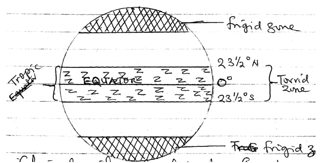
Greek system of climate classification
The system lays emphasis on temperature as a parameter for climate classification. It uses already established boundaries of 00 and 23⅟20 north and south of the equator.
There is a repeat of each climate type on both sides of equator, north and south
This type state clearly the torrid temperate and frigid zone. The temperate zone is regarded by the Greek
classification as the most suitable climate
1. Torrid zone climate
This zone is associated with the tropics. It is hot and records high temperature throughout the year.
2. Temperate zone climate
It is found between the torrid and frigid zone climates. It is of moderate temperature although with seasonal temperature difference
3. Frigid climate zone
This is formed in the polar regions i.e. the Arctic and Antarctic regions.
Throughout the year, it is generally cold and records low temperature. A lot of ice-caps in most part of the year.
(b) Identify three criticisms of the Greek system of climatic classification.
- It is highly simplified
- Only one parameters used i.e. temperature in the classification
- Other elements that are used in considering climate are ignored
- There is over generalization in the system
- The influence of altitude, latitude, vegetation as well as wind system is ignored
- The influence of land forms on climate is rejected by the system
- There is no quantitative approach
- Some other climates like the humid, and desert climates are not recognized
-
-
Question 63 of 67
63. Question
4.(a) Name any four planets in the solar system.
(b)With the aid of appropriate diagrams, explain three proofs to show that the earth is spherical in shape.
-
This response will be reviewed and graded after submission.
Grading can be reviewed and adjusted.Grading can be reviewed and adjusted.Hint
(a) Name any four planets in the solar system.
- Mercury
- Venus
- Earth
- Mars
- Jupiter
- Saturn
- Uranus
- Neptune
- Pluto.
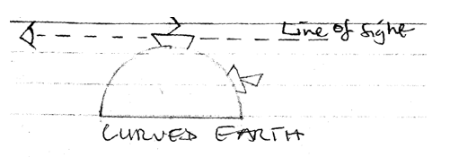
(b) With the aid of appropriate diagrams, explain three proofs to show that the earth is spherical in shape.
1. Aerial photographs
Satellite imagery has revealed that the earth has curved surfaces
2. The eclipse of the moon
When there is eclipse of the moon, the shadow of the earth cast or thrown on the moon is always round. The shadow of a sphere is round and sphere is the only object whose shadow is round. Note that during the moons eclipse, the earth comes in between the sun and the moon.

3. The circumnavigation of the earth
The earth has been circumnavigated several times by air, land and sea. It was Sir Ferdinand Magellan and his crew that first took a voyage round the world between 1519 and 1522. The voyage proved the earth to be spherical in shape and that removed the earlier belief that earth was flat with edges.
4. Sunrise and sunset
The earth rotates form east to west and this means that places in the east of the earth see the sun before those in the west. If the earth were flat, all places would have sunrise at the same time and sunset at the same time.

5. The earths curved horizon
If the earth’s horizon is viewed from the plane or high cliff, it appears curved. The curved horizon widens as viewers altitude increases until it becomes circular. If the earth were flat, the horizon would appear flat and not curved.


6. A ship’s visibility
When two ships approach an observer from afar, the observer sees one first before the other. If the earth were flat, he would see the two ships all at the same time
-
-
Question 64 of 67
64. Question
5.(a) With the aid of a diagram, describe the following:
(i) Sea breeze;
(ii) land breeze.
(b)State two factors that influence the salinity of oceans.
-
This response will be reviewed and graded after submission.
Grading can be reviewed and adjusted.Grading can be reviewed and adjusted.Hint
(a) With the aid of a diagram, describe the following:
(i) Sea breeze


Sea breeze
- During the day, the coast lands become hot
- The temperature of the air over the land increases
- As the air over the land is getting hot at faster rate, the air over the sea becomes warmer at a slower rate.
- As the day progresses, the pressure of the air over the land becomes lower relative to the pressure of the air over the sea.
- A wind blows from the sea to land
- The wind is cool and it is called a sea breeze
- The sea breeze operates during the day.
Land breeze
- At night, the coast land becomes cool i.e. it loses heat faster than water bodies
- Temperature of the air over the sea becomes higher
- As the air over the sea is hotter than that over the land, the pressure of air over the sea is lower than that over the land
- The pressure difference is created
- Hence the wind moves from the land to the sea
- The wind is called land breeze
- It operates at night.
(b) State two factors that influence the salinity of oceans.
- Humidity of the area
- Degree of water mixing
- Rate of evaporation
- Amount of fresh water addition through streams, rivers, rainfall, melting ice.
- Ocean current.
-
-
Question 65 of 67
65. Question
6. (a) Define vulcanicity.
(b) Describe the characteristics and mode of formation of any one of the following features:
(i) Dyke;
(ii) Composite cone.
(b) In what time ways are volcanic rocks important to man?
-
This response will be reviewed and graded after submission.
Grading can be reviewed and adjusted.Grading can be reviewed and adjusted.Hint
(a) Define vulcanicity
Vulcanicity refers to all various ways by which molten rocks and gases are forced into the earth crust and on its surface. It includes volcanic eruption and formation of its features.
(b) Describe the characteristics and mode of formation of any one of the following features:
(i) Dyke
A dyke is a wall-like feature formed when a mass of magma cuts across bedding planes. A dyke is an intrusive igneous rock. It is usually extensive in nature. Dykes are usually formed as a result of intrusion of molten magma into the earth crust through cracks and fissures and solidification of it within the crust and cutting across bedding planes
Good examples of dykes are: Cleveland dyke of Yorkshire(England), Kiang gates ridge in Kuala Lumpar, Isles of Mull and Aran in Scotland, the Dyke of Zimbabwe.
(ii) Composite cone
The composite cone is built up by several eruptions of lava, ashes and other volcano materials from the main conduit which leads down to a reservoir of magma. Every new eruption adds new layer of ashes or lava to the sides of the volcano. As a result of several eruptions which continually adds layers to the side of the volcano, composite cone grows continuously in height from the main conduit, subsidiary pipes could reach the surface as feeders to parasitic cones from where lava escapes to the sides of the main cone.
Good examples of composite cones are the Light-House of the Mediterranean otherwise called Mount Chimborazo and Popacatapeti Mountain.
(b) In what time ways are volcanic rocks important to man?
- The rocks provide primary mineral through weathered and used to form fertile soils for agriculture
- They provide construction materials when quarried
- Crater lakes are housed by volcano rocks
- Used for grinding
- Tourist attraction
- Source of minerals.
-
-
Question 66 of 67
66. Question
7(a) List any four sources of water
(b) Describe any four ways in which water is useful as an environmental resource.
(c) Highlight any five major problems resulting from water pollution.
-
This response will be reviewed and graded after submission.
Grading can be reviewed and adjusted.Grading can be reviewed and adjusted.Hint
(a) List any four sources a of water
- Rainfall
- Spring
- Well
- Lakes
- Rivers, stream
- Oceans
- Seas
- Boreholes
(b) Describe any four ways in which water is useful as an environmental resource.
- For domestic uses e.g. washing, cooking, flushing, drinking e.t.c
- Industrial uses such as textile and pharmaceutical industries
- Water exploitation creates employment
- Provides food such as fishes, crabs, crayfish e.t.c.
- Sources of income for fishermen and associated businesses
- Used for the generation of hydro-electric power(HEP)
- Water bodies are used for transportation of goods and services as well as humans e.t.c.
- Agricultural uses e.g. irrigation
- Recreation purposes and tourism e.g. Bar Beach in lagos
- Used for motor vehicles and engine cooling.
(c) Highlight any five major problems resulting from water pollution.
- Death of aquatic animals and plants
- Eutrophication i.e. destruction of the aesthetic value of water bodies as a result of over growth of water weeds and their death
- The water becomes useless for agricultural purpose
- Presence of water borne disease e.g. cholera
- Migration of people and animals
- Creation of ecological imbalance
- Scarcity of domestic purpose water
- Scarcity of industrial purpose water.
-
-
Question 67 of 67
67. Question
8.(a) Name any four natural hazards
(b) Highlight any three effects of air pollution on man.
(c) In what three ways can air pollution be controlled?
-
This response will be reviewed and graded after submission.
Grading can be reviewed and adjusted.Grading can be reviewed and adjusted.Hint
(a) Name any four natural hazards
- Drought
- Flood
- Earthquakes
- Vulcanicity
- Soil erosion
- Desertification
- Pollution
- Mass wasting
- Global warming and climate change
- Tsunami
- Tornado
- Hurricane
- Hailstone
(b) Highlight any three effects of air pollution on man.
- Causes respiratory tracks infection
- Causes cancer of the skin and lungs
- Creates poor visibility which could cause accident both air and road.
- Source of discomfort to man
- Causes acid rain which is corrosive
- Ozone layer depletion
(c) In what three ways can air pollution be controlled?
- Enactment of laws against uncontrolled emissions
- Use of environment friendly source of power e.g. solar and wind energy.
- Afforestation
- Minimizing bush burning
- Proper disposal and recycling of wastes
- Vehicles with bad exhaust should not be allowed to ply the high way
- Industries should be sited away from residential areas
- International cooperation in the control of air pollution should appropriate
- Fumes from industries should be controlled and treated.
-