


WAEC: GEOGRAPHY
Quizzes
-
2009 Geography WAEC Past Questions CBT
-
2010 Geography WAEC Past Questions CBT
-
2012 Geography WAEC Past Questions CBT
-
2011 Geography WAEC Past Questions CBT
-
2013 Geography WAEC Past Questions CBT
-
2014 Geography WAEC Past Questions CBT
-
2015 Geography WAEC Past Questions CBT
-
2015 Geography WAEC Theory Past Questions CBT
-
2014 Geography WAEC Theory Past Questions CBT
-
2016 Geography WAEC Past Questions CBT
-
2016 Geography WAEC Theory Past Questions CBT
-
2017 Geography WAEC Past Questions CBT
-
2017 Geography WAEC Theory Past Questions CBT
-
2018 Geography WAEC Past Questions CBT
-
2018 Geography WAEC Theory Past Questions CBT
-
2014 Geography WAEC Theory Past Questions*
-
2015 Geography WAEC Theory Past Questions CBT*
-
2016 Geography WAEC Theory Past Questions CBT*
-
2017 Geography WAEC Theory Past Questions CBT*
-
2018 Geography WAEC Theory Past Questions CBT*
-
2019 Geography WAEC Theory Past Questions CBT*
-
2019 Geography WAEC Past Questions CBTdrsoji
-
2020 Geography WAEC Objective Past Questions
-
2020 Geography WAEC Theory Past Questions
-
2014 Geography WAEC Past Questions CBT*
-
2021 Geography WAEC Objective Past Questions
-
2021 Geography WAEC Paper 2 Theory Past Questions
-
2021 Geography WAEC Paper 3 Theory Past Questions
Quiz Summary
0 of 67 Questions completed
Questions:
Information
You have already completed the quiz before. Hence you can not start it again.
Quiz is loading…
You must sign in or sign up to start the quiz.
You must first complete the following:
Results
Results
0 of 67 Questions answered correctly
Your time:
Time has elapsed
You have reached 0 of 0 point(s), (0)
Earned Point(s): 0 of 0, (0)
0 Essay(s) Pending (Possible Point(s): 0)
Categories
- Not categorized 0%
- 1
- 2
- 3
- 4
- 5
- 6
- 7
- 8
- 9
- 10
- 11
- 12
- 13
- 14
- 15
- 16
- 17
- 18
- 19
- 20
- 21
- 22
- 23
- 24
- 25
- 26
- 27
- 28
- 29
- 30
- 31
- 32
- 33
- 34
- 35
- 36
- 37
- 38
- 39
- 40
- 41
- 42
- 43
- 44
- 45
- 46
- 47
- 48
- 49
- 50
- 51
- 52
- 53
- 54
- 55
- 56
- 57
- 58
- 59
- 60
- 61
- 62
- 63
- 64
- 65
- 66
- 67
- Current
- Review
- Answered
- Correct
- Incorrect
-
Question 1 of 67
1. Question
Use the map below to answer questions 1-10
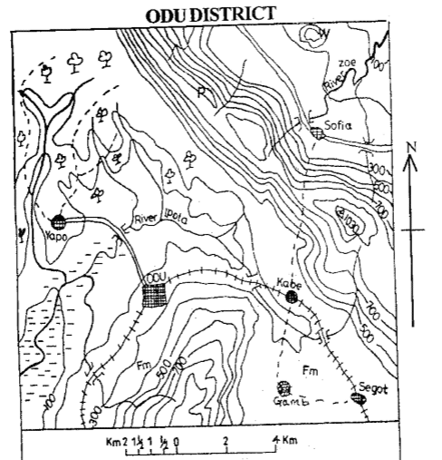

What is the approximate distance by rail from Kabe to Odu?
CorrectIncorrect -
Question 2 of 67
2. Question
The direction of Odu from Sofia is
CorrectIncorrect -
Question 3 of 67
3. Question
What is the scale of the map expressed as Representative Fraction (R.F.)?
CorrectIncorrect -
Question 4 of 67
4. Question
What is the name of the relief feature lettered W?
CorrectIncorrect -
Question 5 of 67
5. Question
The symbol 1030 represents
CorrectIncorrect -
Question 6 of 67
6. Question
Which of the following industries could be set up in Yapo?
CorrectIncorrect -
Question 7 of 67
7. Question
The long stretch of highland to the northeastern part of the map is a
CorrectIncorrect -
Question 8 of 67
8. Question
Which of the following areas is best suited for sugarcane cultivation?
CorrectIncorrect -
Question 9 of 67
9. Question
From which of the following settlements is Odu visible?
CorrectIncorrect -
Question 10 of 67
10. Question
Odu is most likely to be an important trading centre because it is
CorrectIncorrect -
Question 11 of 67
11. Question
Which of the following planets is the farthest from the sun in the solar system?
CorrectIncorrect -
Question 12 of 67
12. Question
What will be the local time in Nigeria 15°E when the time is 7.00 p.m in town Y 30° W?
CorrectIncorrect -
Question 13 of 67
13. Question
The horizontal displacement of blocks of the earth’s crust along a fault plane is called
CorrectIncorrect -
Question 14 of 67
14. Question
The section of the external structure of the earth that supports life is the
CorrectIncorrect -
Question 15 of 67
15. Question
Which of the following are examples of metamorphic rocks?
CorrectIncorrect -
Question 16 of 67
16. Question
The name of the volcanic rock which often forms the root of fold mountains is called
CorrectIncorrect -
Question 17 of 67
17. Question
Which of the following is the most important weathering process in karst regions?
CorrectIncorrect -
Question 18 of 67
18. Question
Which of the following mass wasting process results in curved tree trunks and leaning telegraph poles?
CorrectIncorrect -
Question 19 of 67
19. Question
Which of the following are circular depressions formed on the bed of a river in its upper course by pebbles carried by the river?
CorrectIncorrect -
Question 20 of 67
20. Question
Through what process are rift valleys formed?
CorrectIncorrect -
Question 21 of 67
21. Question
The process by which rocks are disintegrated by physical and chemical means in-situ is known as
CorrectIncorrect -
Question 22 of 67
22. Question
Which of the following is a feature commonly found in the youthful stage of a river?
CorrectIncorrect -
Question 23 of 67
23. Question
The shallow part of the sea adjoining the coast is called
CorrectIncorrect -
Question 24 of 67
24. Question
Most warm ocean currents flow
CorrectIncorrect -
Question 25 of 67
25. Question
Hail, fog, dew and frost are all forms of
CorrectIncorrect -
Question 26 of 67
26. Question
Which of the following elements of weather and climate is matched with the wrong measuring instrument?
CorrectIncorrect -
Question 27 of 67
27. Question
Through which of the following processes does solar energy warm the earth’s surface?
CorrectIncorrect -
Question 28 of 67
28. Question
The release of harmful substances into the environment is called
CorrectIncorrect -
Question 29 of 67
29. Question
Which of the following is the most important agent of erosion in humid regions?
CorrectIncorrect -
Question 30 of 67
30. Question
What is the approximate distance between two places if one is located on 11°N and the other on 5°S on the same longitude?
CorrectIncorrect -
Question 31 of 67
31. Question
The diagram below shows a hypothetical representation of population of selected countries in 2007, 2008 and 2009.
Use the diagram below to answer questions 31 to 33.

The diagrammatic representation above is a
CorrectIncorrect -
Question 32 of 67
32. Question
The population of Canada in 2008 is
CorrectIncorrect -
Question 33 of 67
33. Question
By how much did the population of Germany grow between 2008 and 2009?
CorrectIncorrect -
Question 34 of 67
34. Question
Water pollution is caused by all the following except
CorrectIncorrect -
Question 35 of 67
35. Question
The climate is constantly warm, rainfall is relatively abundant with double maxima, there is no month without rain. These are the characteristics of the
CorrectIncorrect -
Question 36 of 67
36. Question
Which of the following climatic types has the smallest annual range of temperature?
CorrectIncorrect -
Question 37 of 67
37. Question
Which of the following is the first stage in the process of lumbering?
CorrectIncorrect -
Question 38 of 67
38. Question
Which of the following criteria is not important in distinguishing between a village and a town?
CorrectIncorrect -
Question 39 of 67
39. Question
The number of persons per square kilometer of land is called
CorrectIncorrect -
Question 40 of 67
40. Question
Which of the following is a disadvantage of high population density?
CorrectIncorrect -
Question 41 of 67
41. Question
Which factor of industrial location explains the establishment of cement industries near areas of limestone deposit? Proximity to
CorrectIncorrect -
Question 42 of 67
42. Question
Which of the following modes of transportation provides door-to-door services?
CorrectIncorrect -
Question 43 of 67
43. Question
African rivers exhibit the following characteristics except
CorrectIncorrect -
Question 44 of 67
44. Question
What method of mining is used for extracting petroleum in Africa?
CorrectIncorrect -
Question 45 of 67
45. Question
What factor accounts for the slow rate of industrial development in Tropical Africa?
CorrectIncorrect -
Question 46 of 67
46. Question
What is the name of the local wind that blows in West Africa between November and February?
CorrectIncorrect -
Question 47 of 67
47. Question
Which of the following vegetation belts in Africa is the most extensive?
CorrectIncorrect -
Question 48 of 67
48. Question
Through which of the following sea routes is crude oil from West Africa transported to European markets?
CorrectIncorrect -
Question 49 of 67
49. Question
Which of the following towns has winter rainfall and summer drought?
CorrectIncorrect -
Question 50 of 67
50. Question
Favourable factors for lumbering in Africa include all the following except
CorrectIncorrect -
Question 51 of 67
51. Question
1.(a) Outline four functions of an urban centre
(b) Highlight four problems of urbanization.
(c) Suggest possible solutions to any two of the problems identified in (b) above.
-
This response will be reviewed and graded after submission.
Grading can be reviewed and adjusted.Grading can be reviewed and adjusted.Hint
(a) Outline four functions of an urban centre
- provision of high order services
- provision of social amenities
- diffusion of ideas and innovations
- information dissemination
- for recreation and tourism
- Administrative and political functions
- Educational functions
- Industrial functions
- Provide employment
- Commercial function
(b) Highlight four problems of urbanization.
- environmental pollution
- high cost of living
- overcrowding
- traffic congestion
- housing problem
- high crime rate
- increase in social vices
- underemployment and unemployment
- growth of slums and ghettos
- poor sanitation
- rapid spread of diseases
- government expenditure increases
(c) Suggest possible solutions to any two of the problems identified in (b) above.
- introduction of modern agricultural techniques
- enlightenment on pollution
- urban renewal
- development of new towns
- poverty alleviation and job creation
- rapid industrialization
- sanitation laws should be enacted and enforced
- budgetary provisions should be increased by government
- price control measures should be put in place
- waste management system should be properly put in place
- security should be improved
- housing estates should be constructed
-
-
Question 52 of 67
52. Question
2.(a) Highlight any three advantages of each of the following modes of transport:
(i) Rail
(ii) Water
(b) Give any four reasons why some countries in Africa have not been able to sustain their rail transport.
-
This response will be reviewed and graded after submission.
Grading can be reviewed and adjusted.Grading can be reviewed and adjusted.Hint
(a) Highlight any three advantages of each of the following modes of transport:
(i) Rail
- bulky goods are easily transported
- cheap mode of transport
- helps to open new areas
- favours both long and medium distance haulage
- many passengers are easily transported
- not prone to traffic congestion
- relatively safe for passenger traffic
- Maintenance cost is low.
(ii) Water
- It is the cheapest means of transportation
- It allows free passage for all nations
- Good for passenger traffic
- It can carry heavy goods
- It is used for large freight
- It facilitates international trade.
(b) Give any four reasons why some countries in Africa have not been able to sustain their rail transport.
- Inadequate spare parts
- High cost of fueling
- Low patronage
- Dwindling mineral reserves
- Competition with other modes of transport
- Poor management
- Low level of technology
- Maintenance culture is poor
- Government policies not stable
- Non flexibility
- Infrastructural development is high
-
-
Question 53 of 67
53. Question
3.(a) Define international trade,
(b) Describe any five benefits of international trade.
(c) What four factors limit trade between African countries and the United States of America (USA)?
-
This response will be reviewed and graded after submission.
Grading can be reviewed and adjusted.Grading can be reviewed and adjusted.Hint
(a) Define international trade
International trade is the exchange of goods and services among nations. A country can trade with another country or more depending on certain prevailing factors or circumstances of which the degree of need is involved as well as the willingness to trade with each other.
(b) Describe any five benefits of international trade.
- Healthy competition is encouraged
- It encourages specialization
- Exchange of skills expertise
- Ports development is encouraged
- Market horizon widens
- Generate revenue to government
- Encourages industrial growth
- Facilitates development
- Domestic production is stimulated
- Encourages the growth of ancillary services e.g. banking and insurance
- Access to variety of products
- Provides income to traders
- Living standards are improved
- Enhances international cooperation
- Facilitates acquisition of marketing skills
- Foreign exchange earnings
(c) What four factors limit trade between African countries and the United States of America (USA)?
- Competition among other regions
- Strained relationship between countries
- Language barrier
- Inability to produce enough goods
- Cultural taboos/discrimination
- Low purchasing power
- Low demand
- Poor quality of products
- Political will and instability
- High tariffs
- Unfavourable balance of trade
- Crude oil production techniques
-
-
Question 54 of 67
54. Question
4.(a) Draw a sketch map of Nigeria. On the map, show and name:
(i) Any two industrial zones;
(ii) One town in each zone;
(iii) One manufacturing industry in one of the zones
(b) Explain any two factors that favour the location of the industry named in 4(a)(iii) above,
(c) Highlight any four problems facing manufacturing industries in Nigeria.
-
This response will be reviewed and graded after submission.
Grading can be reviewed and adjusted.Grading can be reviewed and adjusted.Hint
(a) Draw a sketch map of Nigeria. On the map, show and name:
(i) Any two industrial zones;
(ii) One town in each zone;
(iii) One manufacturing industry in one of the zones

(b) Explain any two factors that favour the location of the industry named in 4(a)(iii) above
- Nearness to raw materials
- Government policies
- Availability of market
- Availability of labour
- Political stability
- Availability of capital
- Availability of infrastructural facilities
- Presence of power supply
- Presence of water
- Presence of social amenities
(c) Highlight any four problems facing manufacturing industries in Nigeria.
- Insufficient raw materials
- Poor transportation facilities
- Less skilled labour
- Poor management
- Difficulty in accessing loans from banks as well as high interest rate
- High taxation
- Limited market due to low purchasing power
- Limited technology
- Too much interest in foreign goods by the people
- Competition from foreign goods
- High cost of spare parts
- Production of inferior goods
-
-
Question 55 of 67
55. Question
5.(a) Draw an outline map of Nigeria. On it, locate and name:
(i) The Chad Basin;
(ii) The Western Highlands;
(iii) One important town in 5(a)(i) or (ii) above,
(b) Describe the geography of the Western Highlands under the following headings:
(i) Relief;
(ii) Economic activities;
(iii) Problems of development.
-
This response will be reviewed and graded after submission.
Grading can be reviewed and adjusted.Grading can be reviewed and adjusted.Hint
(a) Draw an outline map of Nigeria. On it, locate and name:
(i) The Chad Basin;
(ii) The Western Highlands;
(iii) One important town in 5(a)(i) or (ii) above

An outline map of Nigeria
(b) Describe the geography of the Western Highlands under the following headings:
(i) Relief
- Western highlands are of basement complex rock
- The highest ranges from 300-600m above sea level.
- It is of group of hills like Apata, Idanre, Epinmi hills
- However some of the peaks are over 1000m e.g. Ilesha hills and Idanre hills
- The area is associated with ferruginous soil type
- Some of the hills are of steep slopes
(ii) Economic activities
- The farmers engage in the production of cash crops like kolanut, cocoa, oil palm
- Mining activities takes place e.g. gold at Ilesha, marble at igbeti e.t.c
- Food crops are also grown e.g cassava, yam, and cocoyam e.t.c.
- Due to the presence of grass land, livestock rearing takes place in the northern part.
- Commercial activities are carried out
- Lumbering
- Tourism
- Industrial activities like tobacco, textile, rubber processing
- Quarrying
(iii) Problems of development.
- The problem of lateritic soil which is highly leached and infertile
- Poor physical planning with high population
- Soil erosion
- Land tenure system
- Flooding in urban areas along river valleys
- Low labour force due to high rural-urban migration.
-
-
Question 56 of 67
56. Question
6.(a) Explain any five physical factors that hinder the development of railway transportation in Nigeria.
(b) Highlight any five ways transportation contributes to the economic development of Nigeria
-
This response will be reviewed and graded after submission.
Grading can be reviewed and adjusted.Grading can be reviewed and adjusted.Hint
(a) Explain any five physical factors that hinder the development of railway transportation in Nigeria.
- Rugged terrain
- Flooding
- The presence of many rivers
- Soil erosion and mass movement
- Presence of water logged areas and swamps
(b) Highlight any five ways transportation contributes to the economic development of Nigeria
- Facilitates the movement of people from place to place
- Helps in the opening up of new lands
- It helps to link areas of production and areas of consumption
- Facilitates access to natural resources
- Enhances national development
- Facilitates tourism development
- Ideas and technology diffusion is enhanced
- Movement of goods and services
- Promotes international trade
- Helps to increase gross domestic product (GDP)
- Helps to improve standard of living
- Generates revenue for government
- Promotes dissemination of information
- Facilitates the development of towns
- Provides employment
-
-
Question 57 of 67
57. Question
7. (a) Explain any five factors that are responsible for the population distribution in West Africa.
(b) Outline any five advantages of low population density in some parts of West Africa.
-
This response will be reviewed and graded after submission.
Grading can be reviewed and adjusted.Grading can be reviewed and adjusted.Hint
(a) Explain any five factors that are responsible for the population distribution in West Africa.
- Historical factors
- Soil fertility
- Political reasons
- Availability of higher education institution
- Climate factors
- Mining activities
- Relief (topography)
- Presence of water
- Administration
- Pest and diseases infestation
- Security reasons
- Drainage
- Commerce
- Cultural factors
- How accessible the place is
- Availability of social amenities
(b) Outline any five advantages of low population density in some parts of West Africa.
- Enhanced standard of living
- Decrease in crime rate as well as ease in detection of crime
- Enhanced per capital income
- No traffic congestion
- Reduced/low cost of living because the price of agricultural products are low
- Social cohesion
- Enough resources to take care of existing population
-
-
Question 58 of 67
58. Question
8.(a) Draw an outline map of Africa. On the map, show and name:
(i) Any three rivers important for generating electricity;
(ii) Any two dams on two of the rivers.
(b) Outline any five benefits of hydroelectric power to the people of Africa.
-
This response will be reviewed and graded after submission.
Grading can be reviewed and adjusted.Grading can be reviewed and adjusted.Hint
a) Draw an outline map of Africa. On the map, show and name:
(i) Any three rivers important for generating electricity;
(ii) Any two dams on two of the rivers.
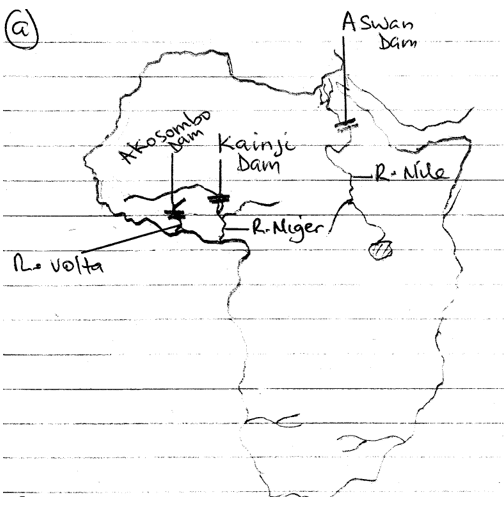
An outline map of Africa showing rivers and dams
(b) Outline any five benefits of hydroelectric power to the people of Africa.
1. Generates employment
2. Provides foreign exchange to government
3.Provides energy for domestic use
4. Improves the standard of living
5. Source of revenue to government
6. Facilitates the growth of settlements
7. Provides energy for offices, ICT (information and communication technology)
8. It provides energy for industrial use
-
-
Question 59 of 67
59. Question
9. (a) Draw a sketch map of Africa. On the map, locate and name any two areas of gold mining in South Africa.
(b) Describe one method of mining gold in South Africa
-
This response will be reviewed and graded after submission.
Grading can be reviewed and adjusted.Grading can be reviewed and adjusted.Hint
(a) Draw a sketch map of Africa. On the map, locate and name any two areas of gold mining in South Africa.
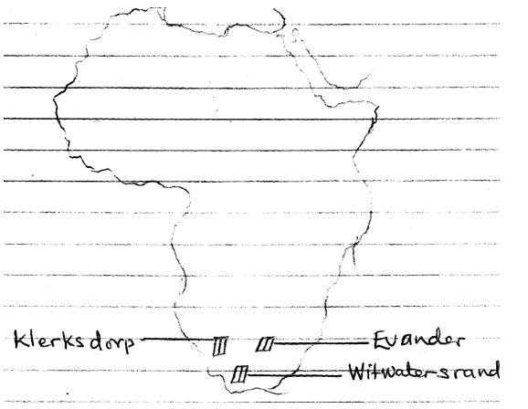
Outline map of Africa showing the gold mining areas in South Africa
(b) Describe one method of mining gold in South Africa
Open cast method:
- This method is applied to where the seam is close to the earth surface
- The overburden is scrapped off
- The gold bearing rock is broken with the use of explosives
- Mechanical shovel is used to load the broken rocks
- The broken rocks are transported to the crushing mill where extraction of the gold is done.
-
-
Question 60 of 67
60. Question
1. Study the map extract on a scale of 1:50,000 and answer the following questions:
(a) Draw an annotated cross profile along line X-Y.
(b) Describe the settlement pattern on the mapped area.
(c) Calculate the full length of river Jamtari.
(d) List three man-made features and three physical features in the area marked by rectangle ABCD.
-
This response will be reviewed and graded after submission.
Grading can be reviewed and adjusted.Grading can be reviewed and adjusted.Hint
Study the map extract on a scale of 1:50,000 and answer the following questions:
(a) Draw an annotated cross profile along line X-Y.

(b) Describe the settlement pattern on the mapped area.
- At the eastern part of the map, there are no settlements because of the high lands
- Most settlement are of isolated buildings and compounds
- Jalingo is built-up area and is the largest of all the settlements
- Jalingo is the only built-up area on the map
- The settlement are found along the main path and are generally dispersed
- Areas liable to flooding are avoided by the settlements.
(c) Calculate the full length of River Jamtari.
From measurement, the length of Jamtari =28cm
Scale of the map is 1cm on the map represents 50,000cm on the ground
- 1cm represents 0.5km
:. 28cm converted to kilometer value using scale of map is (0.5 × 28) km= 14km
Therefore the length of River Jamtari is 14km
(d) List three man-made features and three physical features in the area marked by rectangle ABCD.
(1) The man made features in the area marked ABCD are
- Scattered cultivation
- Settlements
- Main paths
- Foot paths
(2) Physical features in the area marked ABCD
- Valleys
- Spurs
- Ridges
- Main river and tributaries
- Plateau
- Hills
- Forest
- Scrub
- Knoll
- Saddle
- Meander
-
-
Question 61 of 67
61. Question
Four Economic Community of West African States (ECOWAS) member countries contributed to a capital project in the sub-region in 2007 as shown below:

(a) illustrate the information above in a pie chart
(b) State two advantages of using pie chart.
-
This response will be reviewed and graded after submission.
Grading can be reviewed and adjusted.Grading can be reviewed and adjusted.Hint
Four Economic Community of West African States (ECOWAS) member countries contributed to a capital project in the sub-region in 2007 as shown below:
(a) illustrate the information above in a pie chart
Step 1; sum up the contributions of the countries
- 50,000+150,000+110,000+90,000 = $ 400,000
Step 2; calculate for the angles, noting that the sum of the angles in the circle is 3600. Convert each contribution to degrees and use the value to construct a pie chart
- Country A = 50,000/400,000×360/1= 450
- Country B = 150,000/400,000×360/1 = 1350
- Country C= 110,000/400,000 ×360/1 = 990
- Country D =90,000/400,000 × 360/1 =810

A pie chart showing the four(4) ECOWAS countries (A, B, C, D) contribution towards a project in 2007.
(b) State two advantages of using pie chart.
- It is easy to construct
- It aids in making comparison
- It is easy and simple to interpret
- It can be used to show many items
-
-
Question 62 of 67
62. Question
3(a) With the aid of diagrams, explain the following terms in relation to the shape of the earth.
(i) Sunrise and sunset,
(ii) Circumnavigation
(b) Calculate the distance between town A (latitude 5°A0 and town B (latitude 10°N) if they are both situated on the same meridian
-
This response will be reviewed and graded after submission.
Grading can be reviewed and adjusted.Grading can be reviewed and adjusted.Hint
(a) With the aid of diagrams, explain the following terms in relation to the shape of the earth.
(i) Sunrise and sunset
The rotation of the earth causes sunshine and sunset. The sun rises in the east and sets in the west. At different places on the earth, the sun rises and set at different times. People living in the east see the rising sun first before those living in the west. Had been that the earth were flat all the places, east and west, of the earth will see the rising sun and the sunset all at the same time.

(ii) Circumnavigation
Earlier times witness the belief by the ancient people that the world was flat and it had edges. This means those who wise to travel were afraid of not falling off the edge. This belief was proved wrong in the early 16th century when some European sailors, first sir Ferdinand Magellan and his crew, sailed round the world and arrived at the same point they started from or place where they took off; other people like Christopher Columbus, Sir Francis Drake did the same.
(b) Calculate the distance between town A (latitude 5°A0 and town B (latitude 10°N) if they are both situated on the same meridian
Difference In latitude between town A and town B => 100N – 50N =50N
10 of latitude =111km
:. 50 of latitude = (5×111) km = 555km
-
-
Question 63 of 67
63. Question
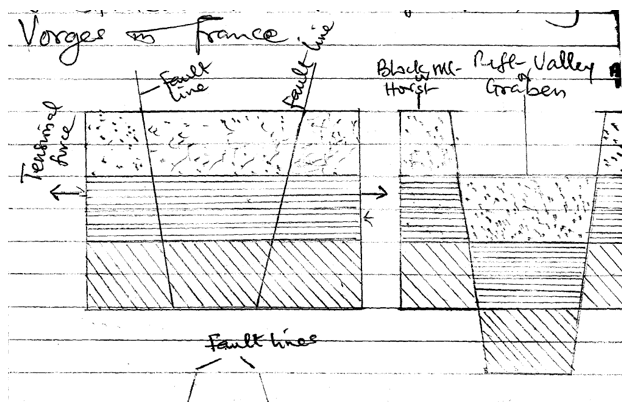
4.(a) With the aid of diagrams, describe one mode of formation of a block mountain.
(b) In what four ways are mountains of economic importance?
-
This response will be reviewed and graded after submission.
Grading can be reviewed and adjusted.Grading can be reviewed and adjusted.Hint
(a) With the aid of diagrams, describe one mode of formation of a block mountain.
Block mountain formation can be achieved through the forces of tension and compression which results from earth’s movement
1. Tensional forces
As the earth moves, tensional forces are generated. The tensional forces facilitate the creation of lines of weakness known as faults on the rocks. On either side of the faults, the tensional forces act. In between two faults is a central block which could subside creating depression called rift valley or graben. The uplifted block on both sides of the graben is called Block Mountain or the horst. The rift valley of east Africa as well as the central valley of Scotland is good examples of tensional forces formed features.
2. Compressional forces
Compressional forces are generated by earth’s movement. As the compressional forces continue to act on the earth’s crust, fault lines are developed. With time, the central block is uplifted as Block Mountain or horst. Good examples of Block Mountains formed due to compressional forces are Forest Mountain of Europe, hunstucks mountain of Germany and vorges in France

(b) In what four ways are mountains of economic importance?
- They provide site for communication mast
- Provide raw material for construction
- Most mountains are water shed
- Tourist centers
- Source of minerals
- Hydro-electric power generation (HEP)
- Provide site for military training.
-
-
Question 64 of 67
64. Question
5(a) Define the term weathering
(b) Describe four processes of chemical weathering.
-
This response will be reviewed and graded after submission.
Grading can be reviewed and adjusted.Grading can be reviewed and adjusted.Hint
(a) Define the term weathering
Weathering is a process whereby rocks are gradually weakened, broken up into smaller fragments either by chemical, physical or biological means in situ.
(b) Describe four processes of chemical weathering.
- Solution
- Oxidation
- Carbonation
- Hydrolysis
- Hydration
- Chelation
1. Carbonation
When rain falls, it mixes with the carbon dioxide in the air to form a mild acid know as carbonic acid. The weak acid reacts with rocks rich in carbonate. This reaction weakens the rocks e.g. limestone which is rich in calcium carbonate on reacting with the weak acid, calcium bicarbonate is form and its disintegration is quite easy.
2. Hydrolysis
Hydrolysis involves hydrogen in the water combining with certain metal ions in a mineral to form different chemical compounds i.e. the water and the mineral react chemically which gives rise to formation of different chemical compounds. Hydrolysis of feldspar gives clay and olivine rock changes to serpentine
3. Hydration
New compounds are formed when some minerals absorb water. For instance hematite which is an iron oxide combines with water to produce limonite which is another iron compound, calcium sulphate absorbs water to give gypsum. Water dissolves some hydrated minerals. However, the minerals from which they are formed are not soluble.
4. Oxidation
Oxidation takes place when oxygen combines with a mineral. Rocks that contain iron combine with oxygen to form iron oxides. Hydrolysis often precedes, and accompanies oxidation. Other weather processes easily attack new minerals formed by oxidation. In the rocks with iron and silicate combination are completely broken down by oxidation of iron.
-
-
Question 65 of 67
65. Question
6.(a) List any two types of delta,
(b) Explain four conditions favourable for the formation of delta.
(c) Describe three main characteristics of a delta.
-
This response will be reviewed and graded after submission.
Grading can be reviewed and adjusted.Grading can be reviewed and adjusted.Hint
(a) List any two types of delta
- Lacustrine
- Estuarine
- Arcuate delta
- Marine
- Birds foot.
(b) Explain four conditions favourable for the formation of delta.
- If the upper course of a river, active lateral and vertical erosion produce sediments
- The features of the lower course of a river
- Prevention of disappearance of sediments by shallow sea
- Large load of sediments are to be carried by flowing river
- A river depositional features
- Tideless coast
- No strong current at the river mouth to remove deposition.
(c) Describe three main characteristics of a delta.
- Delta is a feature associated with lower course of a river
- It is a depositional feature of a river
- It could be of many distributaries
- It has alluvial deposit at the mouth of the river.
- There is presence of shallow water at the delta mouth
- Braiding of rivers into distributaries
- Differ In shape, growth, size and importance
- Estuarine delta is associated with U-shaped channel
- Delta extends seaweeds
- Arcuate delta is associated with fan-shape.
-
-
Question 66 of 67
66. Question
7. Write explanatory notes on flooding under the following:
(a) Areas of occurrence
(b) Causes;
(c) Negative effects;
(d) Control.
-
This response will be reviewed and graded after submission.
Grading can be reviewed and adjusted.Grading can be reviewed and adjusted.Hint
Write explanatory notes on flooding under the following:
(a) Areas of occurrence
- Poorly drained area
- The flood plains of big rivers like river Niger (Nigeria) and Nile (Egypt)
- Regions of delta
- Area that witnesses heavy rainfall
- Coastal area of Nigeria e.g. that is around the southern part, Rivers State
- Where water table is close to the surface.
(b) Causes
- Rise in sea level
- Release of excess water from dams or reservoirs
- Collapse of dams
- Heavy rainfall
- Blockage of drainage and water ways
- Settlement encroachment on water courses
- Ground water coming out from over saturated aquifer
- Rivers over flooring their banks
- Poor drainage system
- Poor urban planning
- Dumping of refuse along water channels
- Melting of ice or snow
- Establishment of settlement on areas liable to flooding
- Poor infiltration
(c) Negative effects
- Destruction of farmlands, houses and properties
- Contamination of domestic sources of water
- Outbreak of diseases
- Loss of lives
- Interruption of economic activities
- Schooling and marketing stoppage
- Shortage of food
- The cost of food is high
- Mud flow and land slide
- People displacement
- Submergence of buildings
- Collapse of building
- Destruction of bridges, roads and railway lines
- Traffic congestion at point of flooding.
- Disruption of ecosystem balance
(d) Control
- Regular clearing of drainage channels
- River course must be dredged to allow free flow of water
- Existing dams should be well maintained
- Rivers should be properly channelized
- Environmental laws should be enforced strictly
- Environment education should seriously be embarked upon
- Proper urban planning
- Enough drainage channels like gutters and culverts should be constructed.
-
-
Question 67 of 67
67. Question
8.(a) Define ecosystem,
(b) Describe any four ways in which man has interfered with the ecosystem.
(c) With specific examples, outline three effects of man’s interference with the ecosystem.
-
This response will be reviewed and graded after submission.
Grading can be reviewed and adjusted.Grading can be reviewed and adjusted.Hint
(a) Define ecosystem
Ecosystem is defined as the interaction between living organisms i.e. flora (plants) and fauna(animals) and their physical environment. The physical environment involves the atmosphere, hydrosphere, and the lithosphere.
(b) Describe any four ways in which man has interfered with the ecosystem.
- Urbanization
- Hunting
- Mining
- Agricultural practices
- Industrialization
- Fishing
- Cloud seeding
- Pollution
- Construction
- Deforestation
- Reclamation of land
(c) With specific examples, outline three effects of man’s interference with the ecosystem.
- Loss of soil fertility
- Pollution
- Soil erosion
- Human migration
- Loss of animals
- Loss of plants
- Animal migration
- Reduction in amount of rainfall
- Loss of farmland
- Destruction of soil structure
- Pressure on available resources
-