


WAEC: GEOGRAPHY
Quizzes
-
2009 Geography WAEC Past Questions CBT
-
2010 Geography WAEC Past Questions CBT
-
2012 Geography WAEC Past Questions CBT
-
2011 Geography WAEC Past Questions CBT
-
2013 Geography WAEC Past Questions CBT
-
2014 Geography WAEC Past Questions CBT
-
2015 Geography WAEC Past Questions CBT
-
2015 Geography WAEC Theory Past Questions CBT
-
2014 Geography WAEC Theory Past Questions CBT
-
2016 Geography WAEC Past Questions CBT
-
2016 Geography WAEC Theory Past Questions CBT
-
2017 Geography WAEC Past Questions CBT
-
2017 Geography WAEC Theory Past Questions CBT
-
2018 Geography WAEC Past Questions CBT
-
2018 Geography WAEC Theory Past Questions CBT
-
2014 Geography WAEC Theory Past Questions*
-
2015 Geography WAEC Theory Past Questions CBT*
-
2016 Geography WAEC Theory Past Questions CBT*
-
2017 Geography WAEC Theory Past Questions CBT*
-
2018 Geography WAEC Theory Past Questions CBT*
-
2019 Geography WAEC Theory Past Questions CBT*
-
2019 Geography WAEC Past Questions CBTdrsoji
-
2020 Geography WAEC Objective Past Questions
-
2020 Geography WAEC Theory Past Questions
-
2014 Geography WAEC Past Questions CBT*
-
2021 Geography WAEC Objective Past Questions
-
2021 Geography WAEC Paper 2 Theory Past Questions
-
2021 Geography WAEC Paper 3 Theory Past Questions
Quiz Summary
0 of 14 Questions completed
Questions:
Information
You have already completed the quiz before. Hence you can not start it again.
Quiz is loading…
You must sign in or sign up to start the quiz.
You must first complete the following:
Results
Results
0 of 14 Questions answered correctly
Your time:
Time has elapsed
You have reached 0 of 0 point(s), (0)
Earned Point(s): 0 of 0, (0)
0 Essay(s) Pending (Possible Point(s): 0)
Categories
- Not categorized 0%
- 1
- 2
- 3
- 4
- 5
- 6
- 7
- 8
- 9
- 10
- 11
- 12
- 13
- 14
- Current
- Review
- Answered
- Correct
- Incorrect
-
Question 1 of 14
1. Question
1. Study the map extract provided on a scale of 1:50,000 and answer the questions that follow
(a)Using a vertical scale of 1cm to represent 200 feet, draw an annotated cross profile of the area marked A-B in the Southern part of the map
(b)Describe the influence of relief area
- settlement in the mapped area
- transportation network in the mapped area
(c)What is the drainage pattern of the mapped area?
-
This response will be reviewed and graded after submission.
Grading can be reviewed and adjusted.Grading can be reviewed and adjusted. -
Question 2 of 14
2. Question
(2)Table 1 contains information in the traffic flow for the movement of passengers from Abuja international airport to other airports in Nigeria in the year 2010. Use it to calculate and construct a flowline chart for the movement of passengers into Figure 1, using a scale of 1mm to represent 10,000 passengers. Table 1: Traffic flow between Abuja international airport and others in Nigeria in the year 2010.

A flow chart showing movement of passengers from Abuja international airport to other airports in Nigeria in the year 2012.

(b) List three advantages of flow charts.
-
This response will be reviewed and graded after submission.
Grading can be reviewed and adjusted.Grading can be reviewed and adjusted. -
-
Question 3 of 14
3. Question
3(a) State the difference between erosion and mass movement
(b) List four agents responsible for modifying landforms
(c) Outline three factors that influence mass movement
-
This response will be reviewed and graded after submission.
Grading can be reviewed and adjusted.Grading can be reviewed and adjusted. -
-
Question 4 of 14
4. Question
4(a) List three characteristic of metamorphic rocks
(b) Describe three modes of formation of metamorphic rocks
(c) Outline three economic benefits of rocks
-
This response will be reviewed and graded after submission.
Grading can be reviewed and adjusted.Grading can be reviewed and adjusted. -
-
Question 5 of 14
5. Question
5(a) With the aid of annotated diagrams, describe the characteristics of the various stages of a river course
(b) List three ways by which rivers are beneficial
-
This response will be reviewed and graded after submission.
Grading can be reviewed and adjusted.Grading can be reviewed and adjusted. -
-
Question 6 of 14
6. Question
6(a) Draw an outline of the Earth and show the following:
- Equator
- Tropic of cancer
- Antartic Circle
(b) Describe three characteristics of line of longitude
(c) A football match for 5.45pm local time on Saturday in Onitsha, Nigeria (Longitude 70E) calculate the local time football fans in Mambola Sierra Leone (Longitude 130W) can tune their radio sets for the commentary.
-
This response will be reviewed and graded after submission.
Grading can be reviewed and adjusted.Grading can be reviewed and adjusted. -
Question 7 of 14
7. Question
7(a) List five sources of water pollution
(b) Highlight five measures that can be taken to control water pollution
-
This response will be reviewed and graded after submission.
Grading can be reviewed and adjusted.Grading can be reviewed and adjusted. -
-
Question 8 of 14
8. Question
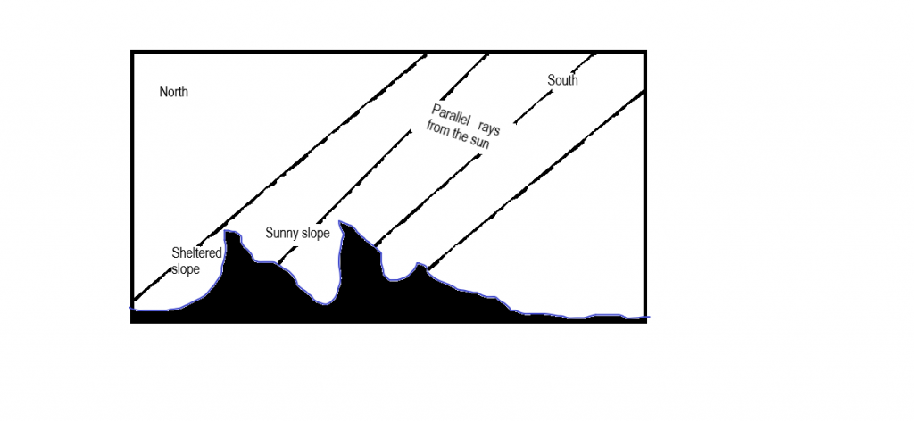
8(a) With the aid of diagrams, explain how the following factors affect the temperature of a place
- latitude
- aspect and slope
-
This response will be reviewed and graded after submission.
Grading can be reviewed and adjusted.Grading can be reviewed and adjusted. -
Question 9 of 14
9. Question
1(a) In three ways, explain how each of the following factors has affected world population
- advanced technology
- improved medical care
(b) Highlight four factors which account for the high density of population in Java
-
This response will be reviewed and graded after submission.
Grading can be reviewed and adjusted.Grading can be reviewed and adjusted. -
Question 10 of 14
10. Question
1(a) State three function each of the following settlements
- urban
- rural
(b) Outline four areas of interdependence between rural and urban centres
-
This response will be reviewed and graded after submission.
Grading can be reviewed and adjusted.Grading can be reviewed and adjusted. -
Question 11 of 14
11. Question
3(a) Explain five reasons why the production of consumer goods is common in developing countries
(b) Outline five factors which influence industrial locations
-
This response will be reviewed and graded after submission.
Grading can be reviewed and adjusted.Grading can be reviewed and adjusted. -
-
Question 12 of 14
12. Question
4(a) Draw a sketch map of Nigeria.
On the map locate and name
- Owerri, Ibadan and Birnin Kebbi
- Cross River and Fadama plains of River Sokoto
(b) Outline four factors that encourage tourism in Nigeria
(c) Highlight three problems hindering tourism in Nigeria.
-
This response will be reviewed and graded after submission.
Grading can be reviewed and adjusted.Grading can be reviewed and adjusted. -
Question 13 of 14
13. Question
5(a) Draw an outline map of Nigeria.
On the map, mark and name:
- the railway line from Ibadan to Kano
- the main road from Port Harcourt to Lagos
(b) Highlight four contributions of transportation in Nigeria
(c) Outline three problems limiting rail transportation in Nigeria
-
This response will be reviewed and graded after submission.
Grading can be reviewed and adjusted.Grading can be reviewed and adjusted. -
Question 14 of 14
14. Question
6. Write a geographical account of Cross River plains under the following headings:
- Climate
- Economic activities
Problems of development
-
This response will be reviewed and graded after submission.
Grading can be reviewed and adjusted.Grading can be reviewed and adjusted.


Help