


WAEC: GEOGRAPHY
Quizzes
-
2009 Geography WAEC Past Questions CBT
-
2010 Geography WAEC Past Questions CBT
-
2012 Geography WAEC Past Questions CBT
-
2011 Geography WAEC Past Questions CBT
-
2013 Geography WAEC Past Questions CBT
-
2014 Geography WAEC Past Questions CBT
-
2015 Geography WAEC Past Questions CBT
-
2015 Geography WAEC Theory Past Questions CBT
-
2014 Geography WAEC Theory Past Questions CBT
-
2016 Geography WAEC Past Questions CBT
-
2016 Geography WAEC Theory Past Questions CBT
-
2017 Geography WAEC Past Questions CBT
-
2017 Geography WAEC Theory Past Questions CBT
-
2018 Geography WAEC Past Questions CBT
-
2018 Geography WAEC Theory Past Questions CBT
-
2014 Geography WAEC Theory Past Questions*
-
2015 Geography WAEC Theory Past Questions CBT*
-
2016 Geography WAEC Theory Past Questions CBT*
-
2017 Geography WAEC Theory Past Questions CBT*
-
2018 Geography WAEC Theory Past Questions CBT*
-
2019 Geography WAEC Theory Past Questions CBT*
-
2019 Geography WAEC Past Questions CBTdrsoji
-
2020 Geography WAEC Objective Past Questions
-
2020 Geography WAEC Theory Past Questions
-
2014 Geography WAEC Past Questions CBT*
-
2021 Geography WAEC Objective Past Questions
-
2021 Geography WAEC Paper 2 Theory Past Questions
-
2021 Geography WAEC Paper 3 Theory Past Questions
Quiz Summary
0 of 14 Questions completed
Questions:
Information
You have already completed the quiz before. Hence you can not start it again.
Quiz is loading…
You must sign in or sign up to start the quiz.
You must first complete the following:
Results
Results
0 of 14 Questions answered correctly
Your time:
Time has elapsed
You have reached 0 of 0 point(s), (0)
Earned Point(s): 0 of 0, (0)
0 Essay(s) Pending (Possible Point(s): 0)
Categories
- Not categorized 0%
- 1
- 2
- 3
- 4
- 5
- 6
- 7
- 8
- 9
- 10
- 11
- 12
- 13
- 14
- Current
- Review
- Answered
- Correct
- Incorrect
-
Question 1 of 14
1. Question
- Study the map extract provided on a scale of 1:50,000 and answer the questions that follow.
(a) On the graph paper provided, draw an annotated cross section from the road junction at AFIENYA to the road junction at Dawhenya (Darwenya).
Describe:
(i)three relief charcteristics of the mapped area
(ii) three drainage characteristics of the mapped area
(iii) with evidence from the map, identify two functions of Doryum settlement.
-
This response will be reviewed and graded after submission.
Grading can be reviewed and adjusted.Grading can be reviewed and adjusted. -
Question 2 of 14
2. Question
2. The Table X below shows the number of farm units three villages of Oju District in the year 2010. Use the data in Table X to answer the questions that follow
Table X
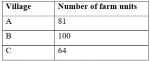
(a) Using the map of Oju District provided on page 3 and radius of 1cm to represent 3 farm units, construct proportional circles to represent the data
(b) State two disadvantages of proportional circles.
-
This response will be reviewed and graded after submission.
Grading can be reviewed and adjusted.Grading can be reviewed and adjusted. -
-
Question 3 of 14
3. Question
Chemically formed sedimentary rocks
Description of Chemically formed sedimentary rocks
(a) Mode of formation: The main minerals for the formation may be from winds, glaciers or streams. This type of sedimentary rock is derived from the accumulation of materials derived from other rocks over a long period of time. These materials are formed through chemical precipitation from other rock solutions. Overtime, these precipitated rocks are accumulated and cemented in layers or strata and become hardened to form chemically formed sedimentary rocks. These strata varies in thickness.
(b) Examples: These are; Sodium Chloride (common salt), nitrates, gypsum or calcium sulphate, potash etc.
(c) Importance: i. source of minerals e.g Gypsum, Potash, Nitrates etc
- Formation of fertile soil e.g potash, nitrates
iii. raw materials for industries e.g Gypsum
-
This response will be reviewed and graded after submission.
Grading can be reviewed and adjusted.Grading can be reviewed and adjusted. -
Question 4 of 14
4. Question
4(a) What is a lake?
(b) Describe the formation of lakes by wind erosion
(c) Identify three benefits of lakes to man
-
This response will be reviewed and graded after submission.
Grading can be reviewed and adjusted.Grading can be reviewed and adjusted. -
-
Question 5 of 14
5. Question
5(a) Highlight four characteristics each of the following:
- time zone
- international dateline
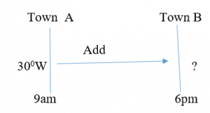
(b) If two towns A and B are located on different time zones and the time in town A is 9.00am while the time in town B is 6.00pm the same day, calculate the longitude of town B if the longitude of town A is 300W.

Time difference = 6pm – 9am
= (18.00 – 9.00)
= 9 hours
Longitude difference = 9 * 150
= 1350
Since Town B is ahead of Town A, Longitude of Town B will definitely be in the East
= 1350 – 300
= 1050
= 1050E
-
This response will be reviewed and graded after submission.
Grading can be reviewed and adjusted.Grading can be reviewed and adjusted. -
Question 6 of 14
6. Question
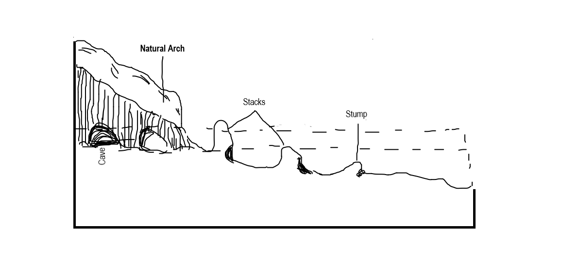
6. With the aid of diagrams, describe the mode of formation of the following features:
(a)stack
(b) fold mountain
-
This response will be reviewed and graded after submission.
Grading can be reviewed and adjusted.Grading can be reviewed and adjusted. -
-
Question 7 of 14
7. Question
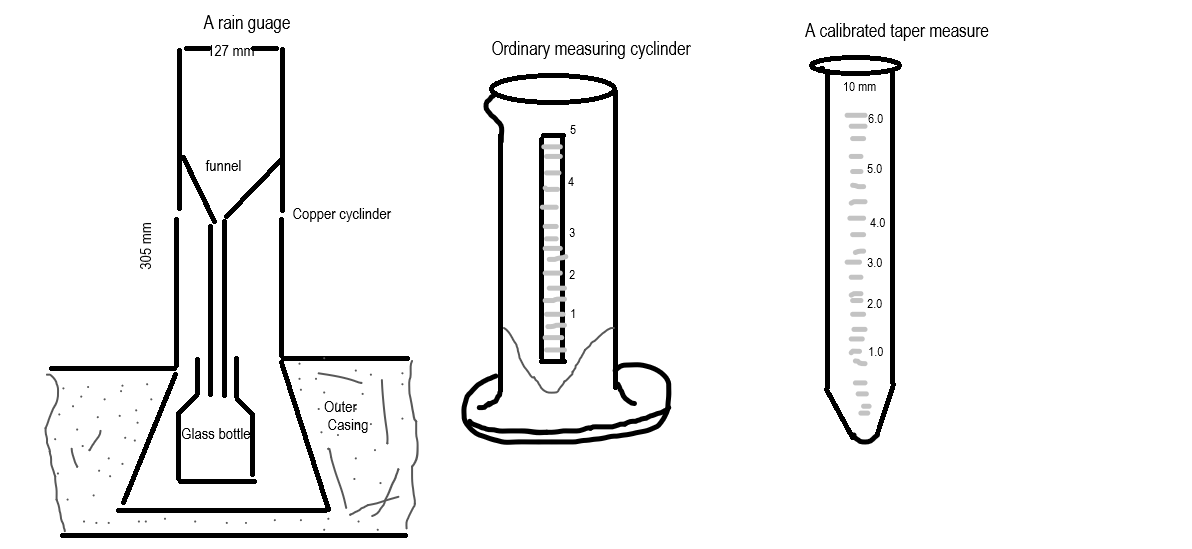
- (a) With the aid of a labeled diagram, describe the weather instrument used to measure the amount of rainfall.
(b) State three precautions which must be taken when using the instrument described in 7(a).
(c) Explain how the instrument described in 7(a) is used to obtain total annual rainfall.
-
This response will be reviewed and graded after submission.
Grading can be reviewed and adjusted.Grading can be reviewed and adjusted. -
Question 8 of 14
8. Question
8(a) Define food chain
(b) Describe the energy flow within a terrestrial ecosystem
(c) Highlight three ways by which nitrogen cycle is maintained in the terrestrial ecosystem
-
This response will be reviewed and graded after submission.
Grading can be reviewed and adjusted.Grading can be reviewed and adjusted. -
-
Question 9 of 14
9. Question
- a) Outline five factors which an industrialist will consider when locating a fruit canning industry
(b) Explain five benefits derived from the concentration of manufacturing industries in urban centres.
-
This response will be reviewed and graded after submission.
Grading can be reviewed and adjusted.Grading can be reviewed and adjusted. -
Question 10 of 14
10. Question
2. The Table 1 below shows the population distribution and land area of five states of country B in the year 2010. Use the data to answer the following questions

(a) Calculate the:
(i)total land area
(ii)population density of country B
(b)Explain four factors that influence the distribution of world human population
(c)Outline three factors that cause increase in world human population
-
This response will be reviewed and graded after submission.
Grading can be reviewed and adjusted.Grading can be reviewed and adjusted. -
-
Question 11 of 14
11. Question
3. Write a geographical account of road transportation under the following headings:
(a)three advantages
(b)three disadvantages
(c)four contributions to development
-
This response will be reviewed and graded after submission.
Grading can be reviewed and adjusted.Grading can be reviewed and adjusted. -
-
Question 12 of 14
12. Question
4(a) Draw a sketch map of Nigeria. On the map, show and name:
(i)one cocoa growing belt
(ii)one groundnut growing belt
(iii)one town in 4(a)(i)
(b) Describe three physical conditions necessary for the cultivation of groundnut
(c) Explain four ways in which groundnut cultivation has contributed to the economy of Nigeria.
-
This response will be reviewed and graded after submission.
Grading can be reviewed and adjusted.Grading can be reviewed and adjusted. -
-
Question 13 of 14
13. Question
5(a) Draw an outline map of Nigeria. On the map, locate and name:
(i) one national park in the north that is important for tourism
(ii) one national park in the south that is important for tourism
(iii) Calabar town
(b) Outline four factors that retard tourism development in Nigeria.
(c) Suggest three ways by which tourism can be promoted in Nigeria.
-
This response will be reviewed and graded after submission.
Grading can be reviewed and adjusted.Grading can be reviewed and adjusted. -
-
Question 14 of 14
14. Question
6. Write a geographical account of mining in Nigeria under the following headings:
(a) Four mineral deposits
(b) One town that is important for the mining of each of the minerals in 6(a)
(c) Three benefits of mining in Nigeria
(d) Three negative effects of mining on the environment of mining areas.
-
This response will be reviewed and graded after submission.
Grading can be reviewed and adjusted.Grading can be reviewed and adjusted. -


Responses