


Quiz Summary
0 of 40 Questions completed
Questions:
Information
You have already completed the quiz before. Hence you can not start it again.
Quiz is loading…
You must sign in or sign up to start the quiz.
You must first complete the following:
Results
Results
0 of 40 Questions answered correctly
Your time:
Time has elapsed
You have reached 0 of 0 point(s), (0)
Earned Point(s): 0 of 0, (0)
0 Essay(s) Pending (Possible Point(s): 0)
Categories
- Not categorized 0%
- 1
- 2
- 3
- 4
- 5
- 6
- 7
- 8
- 9
- 10
- 11
- 12
- 13
- 14
- 15
- 16
- 17
- 18
- 19
- 20
- 21
- 22
- 23
- 24
- 25
- 26
- 27
- 28
- 29
- 30
- 31
- 32
- 33
- 34
- 35
- 36
- 37
- 38
- 39
- 40
- Current
- Review
- Answered
- Correct
- Incorrect
-
Question 1 of 40
1. Question
If a map at a scale of 1:50,000 is reduced by half, what is the scale of the new map?
CorrectIncorrect -
Question 2 of 40
2. Question
Which of the following is not a form of precipitation?
CorrectIncorrect -
Question 3 of 40
3. Question
Which of the following rocks is composed of the skeletons of microscopic sea plants and animals?
CorrectIncorrect -
Question 4 of 40
4. Question
When one looks at a soil profile, the first characteristic to be noticed is soil
CorrectIncorrect -
Question 5 of 40
5. Question
Which of the following areas is subjected to frequent earthquakes?
CorrectIncorrect -
Question 6 of 40
6. Question
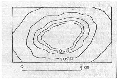
The above diagram on which the contours are in metres shows
CorrectIncorrect -
Question 7 of 40
7. Question
Which of the following countries has a large number of people of African descent?
CorrectIncorrect -
Question 8 of 40
8. Question
When it is 12.00 noon on longitude 300 W, local time on longitude 750 E is
CorrectIncorrect -
Question 9 of 40
9. Question
Large scale migration of people from one country to another may be explained by all of the following except ______
CorrectIncorrect -
Question 10 of 40
10. Question
Urban centres originate mainly as zones of _______
CorrectIncorrect -
Question 11 of 40
11. Question
U and V are two places along the same Meridian on latitude 200N and 250N respectively. The shortest distance between the two places is approximately
CorrectIncorrect -
Question 12 of 40
12. Question
Which of the following statistical mapping techniques is most suitable for showing the spatial distribution of cattle in different northern states of Nigeria?
CorrectIncorrect -
Question 13 of 40
13. Question
The progressive widening of joints and cracks in limestone by solutions, initially leads to the formation of ______
CorrectIncorrect -
Question 14 of 40
14. Question
One of the consequences of global increase in the carbon dioxide content of the atmosphere is _______
CorrectIncorrect -
Question 15 of 40
15. Question
A good overland transportation system promotes economic development because it
CorrectIncorrect -
Question 16 of 40
16. Question
A layer of fine wind-deposited sand and silt is known as
CorrectIncorrect -
Question 17 of 40
17. Question
The most dominant pair of active factors affecting plant growth is
CorrectIncorrect -
Question 18 of 40
18. Question
In what order do the following occur from the surface to the bottom of an oil well?
CorrectIncorrect -
Question 19 of 40
19. Question
The process by which materials are physically transferred from one soil layer to another is called ______
CorrectIncorrect -
Question 20 of 40
20. Question
In Nigeria, geographical location poses the greatest hindrance to economic development in the
CorrectIncorrect -
Question 21 of 40
21. Question
The main use of the Abney level in surveying is to determine
CorrectIncorrect -
Question 22 of 40
22. Question
The most common tree in the desert is the
CorrectIncorrect -
Question 23 of 40
23. Question
A good example of cuesta landscape in Nigeria is
CorrectIncorrect -
Question 24 of 40
24. Question
An example of a rock formed by wood subjected to pressure and heat is
CorrectIncorrect -
Question 25 of 40
25. Question
The most important determinants of air temperature of a region are
CorrectIncorrect -
Question 26 of 40
26. Question


The diagram is a
CorrectIncorrect -
Question 27 of 40
27. Question

The total area covered by the map is approximately
CorrectIncorrect -
Question 28 of 40
28. Question
Which of the following is a type of iron ore?
CorrectIncorrect -
Question 29 of 40
29. Question
A poor settlement on the edge of a city is known as a ________
CorrectIncorrect -
Question 30 of 40
30. Question
A feature produced as a result of glacial deposition is
CorrectIncorrect -
Question 31 of 40
31. Question
The world’s busiest seaport is
CorrectIncorrect -
Question 32 of 40
32. Question
An example of a calcareous rock is
CorrectIncorrect -
Question 33 of 40
33. Question
A boat building industry is least likely to be suitable in
CorrectIncorrect -
Question 34 of 40
34. Question
The most significant economic use of ocean water is for
CorrectIncorrect -
Question 35 of 40
35. Question
The equatorial circumference of the earth is
CorrectIncorrect -
Question 36 of 40
36. Question
The growth rate population is determined by
CorrectIncorrect -
Question 37 of 40
37. Question
A country well known for the production of copper in Africa is
CorrectIncorrect -
Question 38 of 40
38. Question
Which of the following farming systems is likely to give rise to nucleated settlements?
CorrectIncorrect -
Question 39 of 40
39. Question
The feature utilized by a road to cross a flood plain is called ______
CorrectIncorrect -
Question 40 of 40
40. Question
Nigeria’s three steel rolling mills are located around
CorrectIncorrect
Responses